Vegetation History
Of The Atherton Tableland 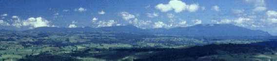
Over the last 100 years forestry, agriculture, waterworks and urban development have replaced or modified large areas of the forest, woodland and savanna which formerly covered the Atherton Tablelands. Even so, we are able to reconstruct the vegetation pattern seen by the earliest European settlers. We can do this by studying the surviving vegetation, whether it be in large tracts or small patches, and by examining historical records.
Rainforest and dry sclerophyll woodland are the two most important natural vegetation types. Rainforest has tall trees which grow close together over an undergrowth of smaller trees and climbers. The leaves of rainforest plants are of various sizes, some being very large, and most are soft. Only a few of the many different kinds of tree shed all their leaves once a year. One example is the Australian cedar (Toona australis). Rainforest has many different kinds of animals as well as plants.
Dry sclerophyll woodland is very different. Its trees are smaller and less closely packed, and the undergrowth is a more diffuse assemblage of low shrubs and grasses. A relatively small number of species occur (mainly eucalypts and their relatives), and leaves of most of the woody plants are rigid and tough.
Other types of natural vegetation are found in the region, notably the taller, denser, sclerophyll forest which inter-fingers with the rainforest. In addition, a great deal of local variation occurs within these main sorts of vegetation. Human interference, such as the logging of forest or clearing land for farms, may encourage some species at the expense of others, or even create an entirely new vegetation. Fast growing trees, for example, may occupy deserted farm land.
Although strongly affected locally by soil type and other variables, the natural boundary between rainforest and dry sclerophyll woodland depends mainly on effective rainfall, the amount of water available to plants after evaporation, soil percolation and run-off have taken their toll. Within the region as a whole effective precipitation is dominated by the total amount of rain, and this diminishes rapidly from east to west; 200 cm a year at Gadgarra, 160 cm a year at Lake Barrine, 140 em a year at Yungaburra and 110 cm a year at Herberton. The natural rainforest boundary lies roughly between 130 cm and 170 em of rain a year.
to wake an intelligent guess about the origins Of the main vegetation types of the Atherton Tablelands, we must use what little is known about the fossil history of Australian plants, and we have to take into account theories concerning the movement -C continents over the world's surface. Rainforest contains two main groups of plants The west recent group consists of species which migrated into Australia during the past ten million years from Southeast Asia. The more ancient group comprises the direct descendants of forest plants which originated when Australia, Antarctica, South America and India were joined into a single, great continent called Gondwanaland.
Australia and Antarctica, the last pieces of Gondwanaland to split apart, finally separated 55 million years ago. Australia has drifted northwards since then, reaching more-or-less its present position in relation to Southeast Asia 10 million years ago. During this time the original forest stock evolved and many living families of plants have been identified from the fossils of these times These include Sapindaceae (hops), Araucariaceae (hoop pines) and Proteaceae (Australian honeysuckles).
Several factors, of which developing aridity was perhaps the most important, slowly reduced to patches along the eastern seaboard of Australia, the area habitable by the ancient rainforest.
One of the ancient Gondwanaland group of families is the Myrtaceae (myrtle family). This is one of the families that was able to take advantage of progressively drier conditions and poor soils by evolving sclerophyllous species suited for such conditions. Eucalypts, Australia's most important plant group and the dominants of dry sclerophyll woodland, are examples of this Australian group.
The distinction between the rainforest on the one hand and dry sclerophyll woodland on the other Is therefore very ancient and of great plant-geographical interest.. Because the rainforest - sclerophyll boundary seems to be controlled by climate, any change in its position during prehistoric time could reflect a change in climate which might still be continuing. Significant natural change in the range of forest trees takes place so slowly that men are unlikely to notice it over their life-span. If we are to study long-term changes in the distribution of vegetation we have to make use of fossil evidence. Pollen grains, because of their wide dispersal, are excellent fossils and are commonly preserved in lake muds.
Much of the Atherton Tableland consists of lava erupted during the last 3 million years. On the Tableland are several volcanic craters, the ends of pipes from which gases, rock fragments and lava were ejected. Some of these craters are edged by well defined ridges and contain lakes. Barrine, Eacham, Quincan and Euramoo are good examples. Other, usually larger, craters are not so well defined and have developed into swamps (eg. Lynch's crater). Crater lakes are excellent sites for pollen analysis.
Material washed into a lake sinks and is deposited in the mud on the bottom. In deep, still lakes the mud, once deposited, remains undisturbed. Mud accumulates year by year, that being deposited in any one year falling on top of the mud in
previous years. The youngest mud is that being laid down now at the top of the mud column.
Mud is a mixture of plant and animal remains, clay and other mineral and organic detritus (including pollen grains) blown into the lake or washed in from the lake edges. Because of the way mud accumulates, a stratified deposit is so that the mud is progressively older as one goes down from the mud-water The change in composition of mud from its surface can itself yield important information about environmental change such as soil erosion or chemical pollution. The history of the forests is told by the pollen grains preserved in the mud
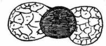
Most plants produce pollen grains which are small, more-or-less spherical bodies about 2 hundredths of a millimetre across (Figure 1). Pollen serves to carry the male reproductive cell from one flower to the female parts of another flower of the same species. When pollen grains are examined tinder a microscope they are seen to come in all imaginable shapes and forms. They may be spherical or angular, they may have pores or furrows or bladders, they may have a silky, smooth or reticulate surface pattern, and so on. All these characters are features of the very resistant, outer-wall of the pollen grain. Each kind of plant produces pollen with a particular wall-structure and we can tell what kind of plant produced a particular sort of pollen. Sometimes we can identify the species of plant from which a pollen grain has come,
but more usually we can identify only the genus or family responsible.
Every year the plants growing in a particular area release millions of pollen grains into the atmosphere. Some fall out of the air very quickly and are deposited on the ground nearby. A very few may be carried high up into the atmosphere to be transported for hundreds of miles before being washed to the ground in rain. Most will fall within a few hundred metres of the plants releasing them. Some pollen from the forest around Lake Barrine falls directly onto the lake surface and some is washed into the lake from the surrounding land.

Australian Cedar
| 
Eucalypt
| 
Black pine
|
Scale: about one hundredth
of a centimetre = 
Figure 1. Sketches of some Australian pollen grains as seen through the microscope.
If we identify and count the pollen falling on Lake Barrine we can estimate the composition Of the forest around the lake. And because pollen preserved in lake muds retains its identity, and grains thousands of years old can be recognised as easily as newly deposited pollen, we can study the composition of the forest formerly around the lake by examining pollen in mud deposited long ago.
Over the past few years we have used a variety of devices to collect mud cores from Lakes Barrine and Eacham. We take sequential samples from along the length of a typical core, each sample being about a cubic centimetre. Because each sample is younger than the samples beneath it we are sampling through time. Every sample is subjected to a series of physical and chemical treatments which concentrate the pollen grains and make them easily visible under a microscope. One sample may contain many thousands of pollen grains. A representative fraction of these is identified avid the quantity of each type identified is determined. The results of all samples are usually combined into a pollen diagram (Figure 2) which shows changes In the quantities of each kind of pollen through the mud core, and therefore through time. Samples of mud from known positions in the core are dated, often by radiocarbon assay. To provide a history of the vegetation around the lake the pollen diagram is interpreted in the light of what we know about pollen production and dispersal at the present day.
RAINFOREST /
SCLEROPHYLL
RATIO
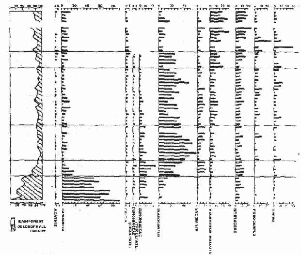
Figure 2. A part of a pollen diagram through the mud of
Quincan Crater from about 7000 years ago at
the bottom to about present day at the top.
Horizontal scales are measures of the abundances
of the named plants (after A.P. Kershaw).
Pollen analysis has been carried out at a number of sites on the Atherton Tableland. Different sites begin their record at different times: Euramoo and Bromfield Swamp about 10,000 years ago; Quincan Crater about 7,000 years ago; and Lynch's Crater more than 100,000 years ago. Together these sites provide one of the few long and detailed records of vegetation history in the tropical world. The most striking events of this history are summarized in Table 1.
Approximate years
before present | Main vegetation characteristics
| | 0 - 80 | European Settlement & Agriculture | | 80 - 10,000 | Complex rainforest with some conifers | | 10,000 - 30,000 | Rainforest with abundant conifers | | 30,000 - 80,000 | Sclerophyll woodland | | 80,000 - 100,000 | Complex rainforest with few conifers | Table 1. Main vegetation changes on the Atherton Tableland during the last hundred millenia
(information from A.P. Kershaw). |
There are three important points to note. First, the distribution pattern of rainforest prior to European settlement had been stable for at least 7000 years. The second point is that between 30,000 and 10,000 years ago, dry sclerophyll wood-land occupied a large part of what had formerly been and was later to be, rainforest; such a big shift in a major vegetation boundary must reflect a climatic change. Finally, the composition of the Tableland rainforest before this sclerophyll period was different from that of later time. In particular, it contained more conifers (eg. Araucaria) and even one (Dacrydium) which is now extinct on the Australian mainland. Much more information can be gleaned from these pollen diagrams, for example about the stability of vegetation (and therefore the animal which live in it) and about climatic and other factors which have changed the vegetation.
Rainforest is the most complex kind of vegetation in the world and the mechanisms by which It maintains itself or changes are of the greatest importance to ecological theory. Obviously, they are crucial to our understanding of tile best ways to maintain timber yields and of how to preserve areas for reserves or parks. One way of studying these mechanisms is to find out how the populations of particular tree species fluctuate through time. Some notion of this can be obtained by estimating the ages of living trees, so determining whether all the species have reproduced together or separately, how long a plant stays in a reproductive stage and so on. Another way is to try to refine the technique of pollen analysis so as to trace the rises and falls in tree populations, at, say, decadal intervals during the last two thousand years. This is methodologically difficult. It requires sites for which the source area of the pollen is well in which mud accumulation has been regular and undisturbed and for which detailed dating can be obtained. Lake Barrine is such a site. Techniques have been developed which allow sufficiently undisturbed samples to be taken from the mud beneath the 65 metres of water at its centre. These muds are very finely layered. Each set of layers may represent a single year's accumulation so that, once this has been proved, it will be possible to date any analysed sample very accurately by counting the layers above it. Other problems also have to be overcome, both in laboratory techniques and in statistical analysis.
The particular characteristics of the Lake Barrine site also provide good conditions for other kinds of investigation. These include studies of changes in the microscopic organisms and chemicals in the lake itself, which indicate some of the things which have been happening in the soils surrounding it. The properties of some of the minerals in the mud record changes in the direction and intensity of the earth's magnetic field. Studies of living plant and animal populations, when integrated with the historical record from the lake mud, will indicate whether disruptions to natural processes result from the isolation of rainforest communities. None of these studies can effectively be carried out in isolation and all build on a general background knowledge of the geology, vegetation, climate and history of the sites themselves and of the Atherton Tableland generally.
The main purpose of all this research is the advancement of human knowledge about the world in which we live. More particularly it is intended to shed light on the processes of change in nature which are persistent, which have produced the patterns of nature in the world as we know them and which we must reckon with In the future.
Additional reading
Breeden, S. and K. A natural history of Australia: 1, Tropical Queensland. Collins, Sydney, 1970.
Flenley, J.R. The equatorial rainforest: a geological history. Butterworths, London, 1979.
Kershaw, A.P. The changing vegetation in Northeastern Queensland. fin See vol. 2 eh 4, 1979 (in press).
Moore, P.D. and Webb, J.A. An illustrated guide to pollen analysis. Hodder and Stoughton, London, 1978.
Pike, G. Pioneers country. Published by the author, Mareeba, 1976.
Russell, K. and R. A lake in the forest. Hisine Technique, Herberton, 1976.
(Prepared by D. Walker, Australian National University, with assistance from colleagues and A.P. Kershaw, Monash University. Research at Lake Barrine was conducted by members of the Australian National University with the collaboration of The National Parks and Wildlife Service of Queensland, CSIR0 Division of Forest Research, the Queensland Department of Forestry and others. 1 September 1979).
|
